

AlpineQuest Off-Road Explorer
June 11, 2024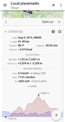
More About AlpineQuest Off-Road Explorer
You can access and store locally a large range of on-line topographic maps, which will remain available even while being out of cell coverage. AlpineQuest also supports many on-board file-based raster map formats.
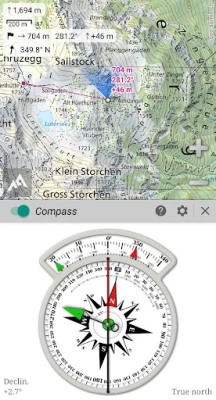
By using the GPS and the magnetic sensor of your device (with compass display), getting lost is part of the past: you are localized in real-time on the map, which can also be oriented to match where you are looking at.
Save and retrieve unlimited placemarks, share them with your friends. Track your path, get advanced statistics and interactive graphics. You won’t have anymore questions about what you can accomplish.
By staying fully operational out of cell coverage (as often in mountain or abroad), AlpineQuest assists you in all your desires of deep wilderness exploring…
Don’t hesitate, try the free Lite version right now!
PLEASE report suggestions and issues on our dedicated forum https://www.alpinequest.net/forum (no registration needed, all questions answered) and not in comments.
Key features are:
★★ Maps ★★
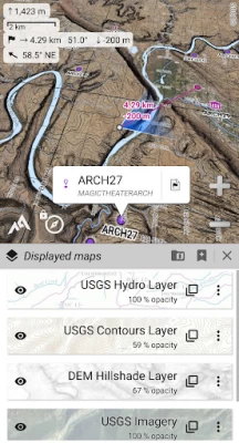
• Built-in online maps (with automatic local storage; road, topo and satellite maps included) and online layers (road names, hillshade, contours);
• Get more online maps and layers in one click from the included community maps list (all major worldwide maps and many local topo maps);
• Complete area storage of online maps for off-line use;
• On-board offline maps support (raster) including KMZ Overlays, OziExplorer OZFx2, OZFx3 (partly) and calibrated images, GeoTiff, GeoPackage GeoPkg, MbTile, SqliteDB and TMS zipped tiles (visit our website to get MOBAC, the free map creator);
• QuickChart Memory Map support (.qct maps only, .qc3 maps not compatible);
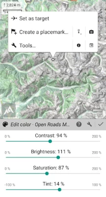
• Built-in image calibration tool to use any scan or picture as a map;
• Digital elevation model on-board storage (1-arcsec SRTM DEM) and support for HGT elevation files (both 1-arcsec and 3-arcsec resolutions) allowing display of terrain, hillshade and steep slopes;
• Polar maps (Arctic and Antarctic) support;
• Multiple maps in layers display, with per-map opacity/contrast/color/tint/blending control.
★★ Placemarks ★★
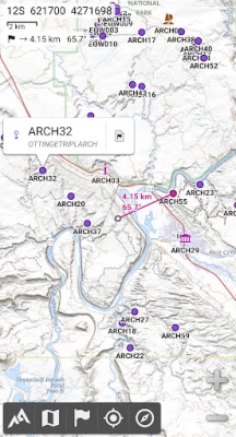
• Create, display, save, restore unlimited number of items (waypoints, routes, areas and tracks);
• Import/export GPX files, Google Earth KML/KMZ files and CSV/TSV files;
• Import ShapeFile SHP/PRJ/DBF, OziExplorer WPT/PLT, GeoJSON, IGC tracks, Geocaching LOC waypoints and export AutoCAD DXF files;
• Save and share online locations with other users using Community Placemarks;
• Details, advanced statistics and interactive graphics on various items;
• Time Controller to replay time-tagged tracks.
★★ GNSS Position / Orientation ★★
• On-map geolocation using device GNSS receivers (GPS/Glonass/Galileo/…) or Network;
• Map orientation, compass and target finder;
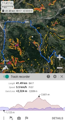
• Built-in GNSS/Barometric track recorder (long tracking capable, running in a separate and light process) with battery level and network strength recording;
• Proximity alerts and leave path alerts;
• Barometer support (compatible devices).
★★ And more ★★
• Metric, imperial, nautical and hybrid distance units;
• Latitude/Longitude and grid coordinate formats (WGS, UTM, MGRS, USNG, OSGB, SK42, Lambert, QTH, …) with on-map grids display;
• Ability to import hundreds of coordinate formats from https://www.spatialreference.org;
• …
Latest Version
2.3.8c
June 11, 2024
Psyberia
Internet
Android
229,038
$12.99
psyberia.alpinequest.full
Report a Problem
User Reviews

Jennifer Hirst
1 year ago
Really useful app. If you download the maps you can use with GPS to track your location, even without a signal. I have successfully used it in Swiss Alps and hiking in Scotland.

Godsmini Relic
1 year ago
Once excellent map app with regular updates and great support. Was great now needs work to move maps from protected folders to somewhere where users can have access without jumping through hoops. Also restore the forums.. removing with no reason given and no update when back is not great. Don't need new app with in app purchases update the existing one!

Dan B
1 year ago
App is superb, perhaps a little bit of a learning curve but capable of anything you would need. Great one-time pricing as well! I have owned the app 5+ years. My primary use is to display OS maps QCT files (the older '80's set that I got from Bittorrent 20 years ago) which are on my device, with google sat layered under (layers can blend, if you have used Photoshop its very similar). One issue recently due to Google changing file permissions, have to move maps to psyberia directory, no biggie

A Google user
6 years ago
I switched to AlpineQuest Pro for Android 8.0 after some difficulties with Gaia. I have used it for about 9 months while bikepacking and backpacking in Nepal, India, and Italy, and for navigating while trail running at home in Oregon. Mostly I use OpenCycleMaps, though occasionally I switch to USGS Topo and Topo Scan for place names, and Google or Bing satellite imagery to trace routes that are not on any layer. The app works wonderfully; it's intuitive and easy to use, fast, not glitchy, and has

Sharon Soule
5 years ago
I would have given this app five stars right up until the May 25th update. I now no longer have the option to save and name a track. Apparently, Alpine Quest is now smarter than me because it supposedly auto saves them. Don't ask me where they go because I can't find them any more. I have to delete all of my tracks to remove them from the screen or my screen gets cluttered with all sorts of tracks over the top of each other. I have Googled it to try and figure it out and it's not worth it.

Joel Snook
4 years ago
I use this to plan hikes and navigate when doing them, as well as recording my training. It is easy to draw routes using the excellent selection of maps and know how long and how hard the hike will be in advance. I import .gpx from hiking sites. I have cached maps for the areas I frequent so I can swich between topos and satellite with no cell. The track editor lets you quickly remove forgetting to turn off recording when you drive home and clean up GPS errors. Best hiking app I've tried.

Mac Belden
2 years ago
Tried many and chose AlpineQ. AQ is not super simple to use, but it was fun figuring out the plethora of features it offers. A little patience with this app goes a long way. Offline navigation is a breeze once you spend a little time with it. Tons and tons of maps with the option of adding other sources or your own. Can't believe it took me so long to find this gem. Also, this is buy and own, not rent-ware like so many of the other nav-apps that don't get close to this one.

rohthomas1
3 years ago
Awesome! I'm a surveyor working in remote areas in the Pacific Northwest. I use AQ constantly when navigating forest roads and searching for old section corners. It is accurate (my Pixel4 gets some credit here, too...) and reliable and displays my agency's GIS layers with ease. The ability to work in State Plane grid coordinates is icing on the cake!

K C
2 years ago
All around Great Offline Gps, different maps and available to save areas in need, maybe adding borders around downloaded areas would be cool so you can see when your out of bounds. Other than that It does save satellite images, topo maps etc. Gpx is good, it can be transfered to Osmand for example for guidance. Proximity Alert is working awesome! And its great for offline!!!

Dillon M
4 years ago
I've been using Alpine Quest for several years now, and it is my favorite mapping program. Waypoints, different background layers, functionality in importing points to and from Google earth pro on my computer, really everything I could want to do with a mapping program, I can do on this app. I prefer it to all the big name mapping programs including Avenza.
A Google user
6 years ago
Best outdoor mapping app. Runs very smooth. So many maps to choose from. DEM data easily stored on device and can be displayed on map in various forms offline. Can utilize device's barometer for an altimeter. Reports uncertainty in current location and will work with GPS turned off based on just network geolocation. I really hope support for maps that show public/private lands are coming soon as it would make other similar apps uneeded.

Chris Reef
2 years ago
Use to be dependable tracking app for hiking in the backcountry. Had no problems for years. Became "pro" from a update. Now it's worthless. It's failed to track my path properly the last 3-4 times i used it. If I was depending on it to get out, I would have got lost. This is a bad review. Avoid this app, could get you killed if your depending on it.

S S
1 year ago
In its various iterations, this has been one of the most consistently useful and valuable android apps I've ever used. It alone made owning a smartphone a worthwhile investment when I first purchased the pro version of the app years ago, and that appraisal remains equally apt today. Loads of useful maps available for use offline. Robust yet intuitive interface. Regular updates and functional improvements. And (hallelujah!) a one-time-purchase model at a very reasonable price point. Kudos!
A Google user
7 years ago
Great by far the best walk or hike mapping app I've used especially for map geeks since it can display pretty much any digital map available and also it never crashes and doesn't chew up CPU while recording unlike several others like MapMyHike, can't tell you how many routes that thing has lost on me due to it crashing or killing the battery. Well worth a purchase. Also one of the VERY few apps aware of the difference between UTM and EGM coordinates, which is especially important when calculating elevation or altitude, because the altitude GPS gives you is based purely on your height above a HYPOTHETICAL NEARLY IDEAL ELLIPSOID that doesn't actually exist in the real world and only very roughly approximates the actual shape of the surface of the Earth, which you need to know in order to calculate true elevation or altitude above ground level (AGL) or altitude above mean sea level (ASL or AMSL) from a pure GPS position source. And this app not only tells you but allows you to select the source of your position, some of which can be wildly incorrect like if your cell tower's position was set in a different coordinate system than your phone expects! Things like that happen more often than you might think since most people aren't even aware of the existence of the many geographical coordinate systems much less the difference between them or how to convert one to the other. It's fairly buried in the settings but in the vast majority of other apps spitting out some value for altitude or elevation you have no idea in which coordinate system that number applies or where the number came from. This app can actually MAP the difference between UTM and EGM with the DEM Heights map overlaid over a topo map. Never heard of any other app that could accomplish that for sure. It continually impresses me more and more the more I use it and figure out how to use its power features.
A Google user
6 years ago
Very simply, the greatest backcountry mapping program available! It can be as simple to use or as in depth as you want it. Easy enough for beginners but enough features for even the most experienced backpacker. Reads hundreds of map formats and you can even make your own maps on a PC using MOBAC. I used to use pdf maps but AlpineQuest is 100 times better and worth every penny. Support is quick, knowledgeable and friendly answering even dumb questions. Get this app!! You wont regret it!

David Larson
4 years ago
AlpineQuest is a quality app. It uses satellites so the app works perfect even without cellular connectivity. The free version was great and caused me to be a big fan of the app, so I gladly paid for the full version to get additional functionality. Don't be afraid to try this app. No ads or spyware, just quality software that will allow you to explore new places with confidence.

Eric N
5 years ago
Amazing App. I use it with Caltopo maps hiking every weekend. Great for finding my route, seeing slope angles. Not quite as slick as an app where you can search a route and immediately see a GPS track, but much more flexible and still easy to import them. Nice to be able to quickly see the elevation difference of nearby points. Haven't used the routing functions enough, but just played with it for the first time in years and I'm impressed. Can easily make a track along trails on a map.

Ernesto O
4 years ago
Really good GPS navigator. The maps and compass feature. It would be 5stars if it was a bit more straight forward to be able to recall waypoints and go to coordinates. Right now it takes too many buttons. I use it for work. There should be a quick press waypoint button since it is the most used featire of a navigation app. I'm still learning how to use it. I'll update.

Steve Leman
2 years ago
Works well, I am happy to have paid for the full version. Includes trail layers and ability to preplan a route, along with easy to download Japan GSI maps. There is a bit of a learning curve and I am not sure I have figured out how to use it optimally, but overall it suits me well. The real-time location saved me a couple times when I went off trail.
A Google user
5 years ago
Fantastic app for bike packing, hiking, dual sport motorcycling. If you dig into the app you can plot trips beforehand telling you elevations between way points, mileage, insert highlighted areas anywhere. Maps are precise and accurate. Works great in airplane mode. Basically you are wherever the dot is and you can plot distances from there. I'm not a GPS geek I just want something that works, easy to use and is accurate. Could care less what Joe blow did and if he had a good time. 5 stars


