

ArcGIS Earth
August 23, 2024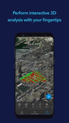
More About ArcGIS Earth
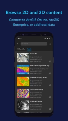
ArcGIS Earth allows you to use a variety of items from ArcGIS Online, ArcGIS Enterprise, local data, and web services:
• Browse web scenes, map services, image services, scene services, and feature services.
• Browse local files including mobile scene packages (MSPK), KML, KMZ, tile packages, and scene layer packages (SLPK).
• Support has been added for Living Atlas of the World.
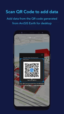
Key features
• Connect to ArcGIS Online or ArcGIS Enterprise.
• Tap to identify features.
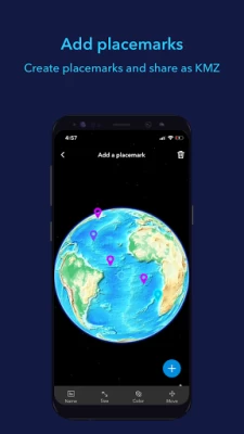
• Support has been added for collecting, editing, and sharing placemarks.
• Interactive analysis tools include Measure, Line of Sight, and Viewshed.
• Create and share tours with geotagged photos.
• Search for places and switch locators.
• Start-up tips and guidance for hand gestures are included.
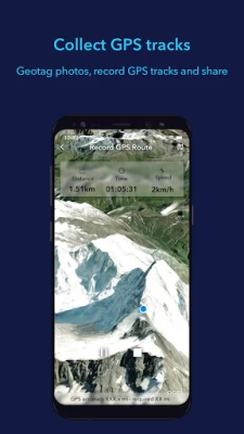
• Record and preview GPS tracks, and share with your organization.
Latest Version
2.1.1
August 23, 2024
Esri
IT Tools
Android
455,094
Free
com.esri.earth.phone
Report a Problem
User Reviews

MIAN ABQ
11 months ago
This app is best example, to show your childrens that how things work in 90's.

Linas Pečkys
4 years ago
LKS Maps does not load up. Please fix! Also, Your app does not understand coordinates in the search! Please add this feature

Mach Mayual
10 months ago
Totally awesome app. Thank you

Jennifer Welsh
4 years ago
Data constantly fails to load. It also tells me that data roaming is turn on when in reality my data roaming is turned off. Running this app on Andriod A20

A Google user
5 years ago
Worked for 5 minutes and now it keeps crashing. I also tried to upload a KMZ file, which it supports but the layer never appeared

nerkedwards
4 years ago
This app seems to work flawlessly on the iPhone, but every local file I try to load says "Failed to Load" no matter how I try to bring it in. Every file type I have tried, KMZ, KML, SLPK. Wish it worked on Android...

Nelson B
3 years ago
Long time ESRI user, decent app however I expected alot more. In particular theres no option for different coordinate systems, for instance MGRS. It's been 2 years since someone brought this up and still no fix.

Jacob Bingham (UFTS)
1 year ago
Performs really terribly, even though it's 2D imagery, the base map brings my device to its knees (~3 fps) at max zoom, while Google Earth manages 20 fps with max detail, 3D imagery

Jitan Dahal
3 years ago
Nice experience to have it in phone. There was a delay in getting the placematk renamed. It somewhat appears a little slow most of the time. Hope it will be fixed in next updates.

Elizabeth Boone
4 years ago
I know that this app has a lot of cool tools for mapping and other, but nothing will show up on the map portion. It is just a black screen. How am I suppost to use this app as a tool when I cant see anything on it?
A Google user
5 years ago
I just installed this app in order to view trail map in kmz format...the file is not being loaded when I browse it using ' Add Files'. Not sure what's wrong as there is no message about anything. There is simply no action. Please let me know if I am taking incorrect action.

Dexter Gordon
2 years ago
Am disappointed that I have to go through the process of logging in very often. I'm not sure if that is due to instability within the app other conditions. Folks, We have big hands. It's hard to log in on a small virtual keyboard.

Calin Agotici
2 years ago
Spotty performance. There is a bug in the 3D measuremtns tool. I measured vertical distance ore a body of water and when I got far enough away from the starting point the reading went from 1-2 meters to 1-2 km. i even saw distances of hundreds of km vertical distance.

caue “a levix cauema cregox” rego
4 years ago
can't find anything about being open source, that's only a "licensed for developers use only" warning on the top, and it looks like esri only has proprietary software. much to the opposite of what i was hoping for and what i know it's the only way forward for the world. seem to be well since otherwise, but i can't bother to try it with these conditions. ~cregox

Craig H
1 year ago
App barely functions on Android. Tried to search for a specific location wasn't even able to type the whole name in. Maybe ok on a PC or laptop definitely not ready for mobile unfortunately.
A Google user
5 years ago
Needs still some improvement. Overall it's good to seem the 3d data to view and interact seamlessly. But after I added multiple datasets the basemap is not showing up anymore and all I can see is grdilines without the basemap even if i closed the app sign out. I could remove the datasets now and the basemap shows. However once the data is added from the organisation and if I sign out the data is still available showing info. It should remove the data layers if we sign out.

Jordan Crittenden
1 year ago
just downloaded to my android and tried to explore the pyramids, froze immediately. app doesn't work.

Debarun Banerjee
4 years ago
I have tried other GIS apps, found this one to be the most polished amongst them, with good enough tools. But if I try to load any layer from the portal it is taking me to a web login page, even though I am logged in the app, and fails to load any layer. This could easily have been a six star app, no doubt.

Christopher James Rawn
4 years ago
I love this app. I had it in beta a couple years back but somehow lost it after my phone was stolen for the umpteenth time. But I digress... I got it installed again and I'm very happy with how it's progressed since last I used it. Much more stable than previously was the case. I also like the feature wherein you can use .kml files - just like Google earth. An excellent app. I definitely suggest you install it today.

LAWRENCE
11 months ago
Yes, good. However, if I start the app without an internet connection, it has no background and icons for waypoints won't show up. If you can, provide a basic darker background to load as default without internet. Try to get icons to load from kmz. OK, other than this I would give it a 5.


