

Avia Maps Aeronautical Charts
June 28, 2024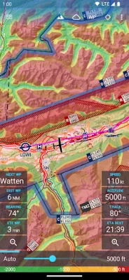
More About Avia Maps Aeronautical Charts
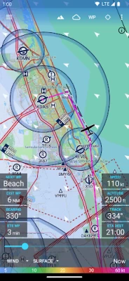
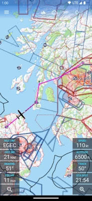
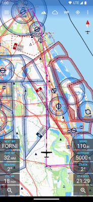
A digital elevation model supports you with planning your route in the mountains. During flight the terrain overlay will dynamically color hills and mountains on the map depending on your current altitude to increase your situational awareness.
To enhance safety, Avia Maps can display traffic information from your favorite ADS-B receiver or from the SafeSky app directly on the map. It supports receiving traffic data using the GDL90 format, which is supported by most portable ADS-B receivers like SkyEcho or Stratux. If you do not have a receiver, SafeSky can provide traffic data using an internet connection only.
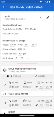
For the most accurate performance calculations you can create multiple aircraft profiles from handbook values for climb performance, fuel consumption etc. Route calculations will use these profiles and even consider engine type and fuel burn for climb performance, employing common formulae used in aerospace engineering. From as little as four carefully chosen data points the app can accurately recreate the climb performance diagram in your POH.
For clarity and commonality to paper charts the map is themed in the style of ICAO Annex 4 (Aeronautical Charts). If you use the app on multiple devices you can synchronize your routes, aircraft profiles and user waypoints between them.
This is a trial app with full features. After an evaluation period of 30 days you will have to buy a perpetual license from within the app or subscribe to the professional tier.
Latest Version
3.12.5
June 28, 2024
Remy Webservices UG
Internet
Android
168,138
Free
com.mytowntonight.aviamap
Report a Problem
User Reviews

V Racan
4 years ago
Just what I needed a simple aeronautical gps navigable VTA nav chart showing controlled airspace and zones, and can find locations by entering co-ordinates too. Now I can easlily see in what class airspace without having the inconvenience of opening my vta map while flying. Simply Superb! Thankyou very much guys.

Juraj Zervan
3 years ago
I like this app very much! I am missing just one thing, and that is elevation data on any point I click (in the info box). Other than that, for the price this is a pretty sweet deal and great backup. I like the color theme very much as its very close to official aero maps in our country!

A Google user
6 years ago
I am a happy user of Aviation weather and definitely will be buying this one too. Comparing to Air Navigation Pro this app is way better (really 10 times faster rendering) and price wise it is infinitely better. P.S. To those babies who put one star because something does not work - learn how to e-mail to support. Seriously you do nothing good but just hurting development for no real reason. One star is when you hate design or decisions made, not when you can't download maps.
A Google user
6 years ago
Very promising app, but no chance to download the maps. Tried with WiFi connection, without WiFi connection... the app simply wastes your time by letting you wait. Tried and tried and tried again. I even changed at least 3 different WiFi connections. Nothing. I'm willingly to try again... when and if it will work. Samsung Galaxy S9+
A Google user
6 years ago
Great user experience. Thank you guys. I have only been using it for 30 mins, so apologies if I have missed something. A few thing I would like to see: 1. Save way points and custom way points. 2. Locking North up so you can't rotate the screen accidently. 3. Runways with their numbers at each end. 4. When clicking on a particular point, the frequency should come up. Great value for money. You can send me an email for other advices. Many thanks once again. South Africa.
A Google user
5 years ago
I downloaded this app a few days ago. I like the price for after the one month period. No problem there. The problem is even after I downloaded all the zoomed charts of the 3 squares I typically fly in Ontario, I was very dissapointed to find the lack of details for a private pilot like me. I need names of all towns, names of lakes, etc. I need an option at very least to have a VNC and also VTAs of different cities. What pilot is this aimed at?
A Google user
6 years ago
This product is great for VFR flying, but when you need to do IFR planning, I don't need to see roads and cities and all that extra info. All I really care about are airports, airspace, NAVAIDS, airways, and way points. If you can throw some WX overlays on there, that would be awesome!!
A Google user
5 years ago
No easy way to save waypoint names. Needs a distance from a point on the map. E.g. Click anywhere and tells you location and distance. Would be great if one of the data fields was closest VRP. Needs a way to export and import settings, sometimes i plan on phone and want to resume on tablet. Otherwise it's good.
A Google user
6 years ago
This app could be great. Their email support seems to be non-existant as I've sent them a few emails with no response. Not filling me with confidence after buying the app. The ability to add your private or local flying school would be a great help. Adding notams and filing of flight plans would also be a great bonus. This could be a 5 star app. EDIT: I appreciate the feedback from developer I think once upgrades happen this will be an excellent app and a top contender to the other apps out there
A Google user
6 years ago
Lovely simple and clear app. Hope the devs can add in Notams and track recording and export. Really competitively priced compared to the competition but the lack of Notams is an issue if you really did want to use it for flight planning. Have bought the app and emailed support: How to transfer routes between devices? Disappointed not to get a response.

Anders Olofsson
5 years ago
Works great, tried it on my Lenovo M8 tab, android 9. (Only tried free version yet). Pros: 1. Fairly easy to use. 2. No monthly/yearly fee. Cons (minors): 1. Could not get map to follow aircraft (I'm pretty sure I missed something/did something wrong, I tried double tapping aircraft symbol). 2. Zooming and rotating map occurs at screen center, not where your fingers are pinching on map. 3. No runway numbers or taxiway letters when at max zoom in. 4. A bigger/larger max zoom out level could be useful (at longer routes I cant see my origin and destination simultaneously). Maybe a userdefinable max in/out zoom? 5. Not sure if being able to edit route while flying is good or bad, nice to adjust route "on the go" but can also be annoying, "oups I accidently added a waypoint". Could have a separate edit mode and normal mode (flying).

Pieter Kotzé
5 years ago
I have just started using it. Looking for a simple and affordable planning tool to check distances and travel times. Willing to sacrifice map detail and eye candy for price as I will use it maybe 10 times a year, so a subscription service is not needed. This app seems to be pretty close to that. 1. Would be nice to enter waypoints using ICAO identifiers. 2. Would be nice to move or drag waypoints in flightplan to different sequence.

Anjum Shaikh
4 years ago
I had installed and evaluated atleast half a dozen apps for flying over the last couple of years. I was looking for something that didn't charge me an annual licence fees, was easy to use in flight and for any preflight planning, was accurate, had regular updates and had really high resolution maps. I was ever so delighted to find this app. It ticked all the boxes and is well worth the money, as it has life time validity. Thanks, keep it up 🙂👍🏼

Whisky Actual
1 year ago
This is my favorite Aviation map app on Android since we don't get Foreflight. I've had this for about a week, and the only issue I have is that it does not track the course that you've flown like foreflight does. Or at least it does not work for me. I also like how you can pair this with Avia Weather that gives you the METAR/TAF for a selected airport

Anthony Aldama
3 years ago
Want to give five stars but it's lacking some very important features. As far as I'm aware, there is no nighttime mode, so if you fly at night you will have a ton of white light coming out of this app, which we all know destroys night vision, even on low brightness, so this app is almost useless at night. Second, it does not display obstacles on your route. There are several cell towers in my area that go all the way up to 2,000 feet, yet they are not displayed. Very dangerous!
A Google user
6 years ago
An extremely high quality app with a bright future. I would love to see save-able and re-nameable custom waypoints (currently custom waypoints are auto-named Waypoint 1, 2, 3, etc.) and more aviation-related items on the map (obstructions, MSAs, etc). I love the integration with Avia Weather. Very well done!
A Google user
6 years ago
Likely the best aviation maps on Android. There are quite a few areas the app can be improved on, but it is definitely step in the right direction. It is currently lacking features that apps such as ForeFlight offers and simpler things like being able to zoom in/out to a desired size instead of predefined zoom positions, loading the areas all over again when paning over the map (by keeping it in cache for example) etc can be improved upon. Excited to see what this app can become.
A Google user
6 years ago
EDIT 3/12/19 Emailed the developer about my issues with the trial period. He immediately looked into it and reset the trial period so that I could use the app. Now that I'm able to use it I have to say WOW!! Very clean interface, easy to use and tons of features! Not to mention excellent customer service as he handled my issue quickly. Well done!

Jacob Dickey
4 years ago
UPDATE: The good: Fantastic UI/UX, reliability, readability. It has THE BEST designed vector maps (colors, layout, icons, markers) I've seen in an EFB. Customer service is exceptionally responsive. The bad: It only uses Android native GPS data. If you use an external GPS provider that Android recognizes natively, it should work, however it is blind to ADS-B/GDL90 data as well as SimConnect data from programs like Xmapsy rendering it useless for real world and simulated flight. On the ground, this app is A++, 5 stars. In the air or in the sim, it is not practical.

Bee M
1 year ago
Awesome tool! Everything about it is good. The weather reports are easy to get from anywhere because the option pops up on most airports. The features enable map dowloading national. It does use mych storage so just go with what you need if on a phone. The airport data is wonderful. I have learned more about flight distance and precautions from using this than any other tool. It is well worth supporting and add ons are not expensive .


