
BackCountry Navigator GPS PRO
July 22, 2024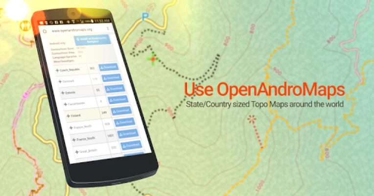
More About BackCountry Navigator GPS PRO
New: Android Wear support to see navigation at a glance on wrist
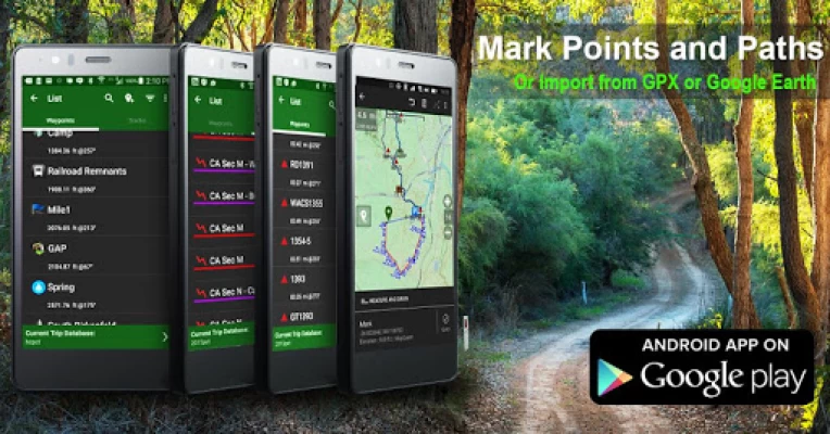
Use GPS waypoints from GPX or KML files, or enter your own coordinates using longitude/latitude, UTM, MGRS, or grid reference. Using GOTO makes a waypoint a locus for navigation.
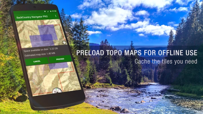
This uses many publicly available map sources as free downloads. Some additional content available as an in app purchase:
-Accuterra Topo Map Source for $19.99/year. This can be purchased and used with or in instead of the free sources.
-Thunderforest Map Sources - worldwide for $11.99 per year.
- Boundary maps for 12 western states from the Bureau of Land Management(BLM) Overlay for topo maps valued by hunters.
-GMU boundaries in some states
-Lake Contours in several states.
-Content from US TrailMaps including:
-ATV, Whitewater, and Equestrian Trail Maps
See the menu under More-> "Purchasing AddOns". They can be shown on top of topo maps.
You may try the DEMO version to make sure you like the maps in your country.
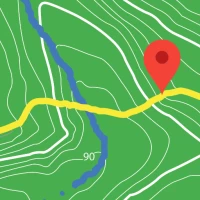
About topo (topographic) maps: Topo maps show terrain through color and contours, and are useful for navigation offroad. Topo maps and GPS can be used for hiking, hunting, kayaking, snowshoeing, & backpacker trails.
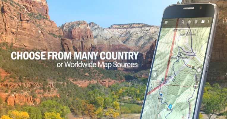
You can create your own maps with Mobile Atlas Creator, or specify a custom tile server. Built in sources include:
OpenStreetMaps from MapQuest
OpenCycleMaps showing terrain worldwide
US Topo Maps from Caltopo and the USGS
USTopo: Aerial Photography with markup.
Canada Topo Maps from Toporama
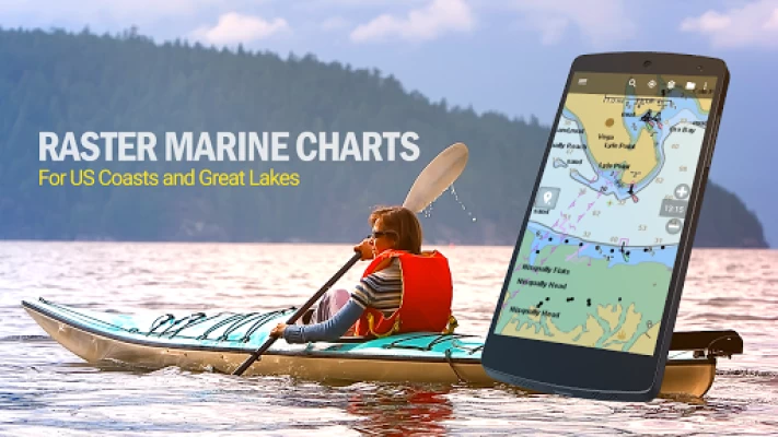
Marine maps: NOAA RNC Nautical Charts (coastal)
USGS Color Aerial photography
Topographic Maps of Spain and Italy
Topo maps of New Zealand
Japan GSI maps.
Many of the above sources are generally free to use.
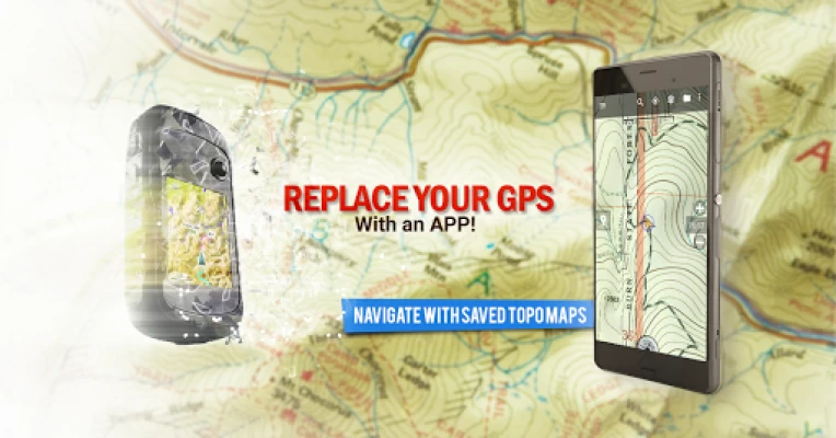
Use offline topo maps and GPS on hiking trails without cell service. The GPS in your Android phone can get its position from GPS satellites, and you don’t have to rely on your data plan to get maps. Have more fun and safe GPS navigation in the backcountry.
Use as a geocaching navigator by getting a pocket query as GPX.
Besides geocaching, use GPS for recording tracks and GPS waypoints on your trip, all the while tracking your GPS quest on topographic maps. It may replace your Garmin handheld GPS.
Here are some of the outdoor GPS activities BackCountry Navigator has been used for:
As a hiking GPS both on hiking trails and off trail.
Camping trips to find that perfect camping site or the way back to camp with GPS.
Hunting trips for hunting wild game in rugged areas.
Doing recon for a hunt or as your hunting GPS
Fishing: make it your fishing GPS.
Search and Rescue (SAR).
Trekking the Pacific Crest trail or other long term hiking.
Kayak and canoe treks on inland lakes and streams or marine, coastal waters.
Backpacker trips: using topo maps of wilderness areas and national forests for navigation on trails with the GPS in your rucksack or backpack.
Find your own ways to have fun in the outdoors. Be a maverick by venturing beyond cell service boundaries with your GPS. Become a pro at navigation with GPS for the outdoors.
BackCountry Navigator has been on WM devices and preloaded on the Trimble Nomad outdoor rugged device. This Android version is more flexible, featured, and fun. Create a memory with maps.
For a one time fee, this a great addition to the outdoor gear you bought at Cabelas, REI, or another outdoor store. Many have found the Android GPS in a phone or tablet to substitute for a Garmin GPS or Magellan GPS, such as the Garmin GPS units Montana, Etrex, or Oregon. Android can be your handheld GPS.
Latest Version
7.5.9
July 22, 2024
CritterMap Software LLC
Internet
Android
247,346
$14.99
com.crittermap.backcountrynavigator.license
Report a Problem
User Reviews

T
3 years ago
UPDATE (8/21/2022): Devs troubleshot with me and it turned out that having a large downloaded map file in my data folder was causing this crash when trying to migrate. Try this is having issues. An amazing app for low battery usage GPS tracking for hikes. BUT, whoever is in charge of updates has done a huge disservice to the excellent programmers that made this app. I took my phone on a new hike and was planning to use it for the hike, but the app would not open...

A Google user
6 years ago
Disappointed, I have always loved this tracking, until yesterday. I use it when I ride horse to track my miles along with mapping my ride. Yesterday it didn't map my ride correctly and it did get the miles correct. I thought it was because I needed to update it, but that is not the case. I paid for this app, so I wouldn't have to worry about it not working for me, like it has always worked wonderful in the past.
A Google user
6 years ago
Have been a huge fan of BCN Pro for 4 yrs+. The tracking has recently stopped working. When tracking first starts it works until phone screen times out or you purposely close your screen, such as when you want to put it in your pocket. The tracking then freezes & no longer records. This happens on both my Samsung Galaxy S8 & S10. update 5/04/19: yes that worked! thank you very much!
A Google user
6 years ago
I really like BCN. I've used it for years and works well. Its done everything I've asked. There is a learning curve. Very flexible and gets the job done. With that I feel that they've let it get out dated due to their new focus on XE software coming out someday. Look at their website and you'll notice things haven't been touched in years. Not a lot of refinements or updates specially when there's a lot of competition- Gaia, LeadNav and a lot of others.

Gus Lee
3 years ago
Works well when it works...But since the last Android update, BCN doesn't seem to play well with the power saving features. Had alot of headache trying to get it to work properly tweaking multiple power saving settings. I'm sure Android is partially at fault here, but from the user's perspective, I would expect app/OS updates shouldn't have to be so difficult.

Todd Silimperi
4 years ago
Great app! I happily paid $10 for the Pro version. I've taken 6-7 hour canoe trips and recorded my track the entire way, sampling every minute. No battery issues. My only complaint is the custom icons for waypoints are stupid. There are icons for places that are clearly limited to Urban areas, not the backcountry. Also, the icon pictures were poorly chosen. They were clearly made by someone who is not an outdoors person. For example, there's an icon for "butcher". Huh?
A Google user
6 years ago
All these gps tools with offline maps are a bit quirky. However this one has consistently worked well for me. I paid for the accuterra maps and that has really made the difference. I really like being able to name map packages and then switching to the relevant map for my trip. Same thing goes for the trip database and waypoints. I do wish that Google maps were available. They are of little value in the Backcountry but it is easier to locate places with them.

Herbert Schroeder
3 years ago
I'm upgrading this to 5 stars. After much searching I finally located an Android setting under App Battery Usage, which needs to be set to Unlimited. With this tweak the app works as it used to. [Original post: This used to be a great app, but at some point the GPS location and track recording functions stopped working correctly. Now my recorded tracks are wildly inaccurate, making the app virtually useless for me. Very disappointing.]

Steve Rowe
4 years ago
I have used this app for several years now and have found it quite helpful in tracking where I am on backcountry trails. I have tried several other Topographical GPS apps, and have found not one that I would replace this one with. The choice of maps has changed recently due to 3rd parties, but there are still good choices for trail maps (which is all I use this for). The user interface is not always easy to decipher, but once you get used to it, the interface makes more sense. Also there are very nice explanations for what the various options are in the user interface, so it becomes fairly easy once you've used this app for a while. I think buying the Pro version was worth the money.
A Google user
6 years ago
This app is awesome! I use this on my phone and I have a handheld garmin GPS, using them side by side, obviously I much prefer the screen size, brightness and responsiveness of my phone. Be sure to download your map ahead of time. While youre on the trail turn off mobile data, bluetooth, etc. Leave location services enabled. I also use the battery saver mode and can get my phone to go a few days without a charge. I always carry a backup battery just incase.

Smokey Bear GE
3 years ago
This app used to be great. I used it internationally with success, but now I agree with Gus Lee's review that erant lines and unreliable behavior is common. It will just stop tracking in less than difficult terrain too. Lately, I cannot get BC Navigator to download areas selected for download. It just never finishes. Time to choose a new app. Any suggestions are welcome.

Tim Brandis
3 years ago
Wow, after reading other reviews it almost seems redundant to point out that recent updates to the app or Android have left this app completely dysfunctional and worthless. I have been unable to download any new maps, tracking for me has been mostly reliable, but I am unable to contact support and share the logs of the trouble. All of this after years and years of flawless reliability. What the hell happened?

Bryden Cais
3 years ago
Used and loved this app for 7 years, and had recently been using it in search and rescue. Folder migration failed, and lost 7 years worth of downloaded maps. I can no longer access the (better IMHO) green FS topo maps as they seem to have all been replaced with newer white/ brown ones. Contacted support, waited a week with no reply, contacted again, still waiting on reply. Seems like support is non existent, and a one great app is now garbage.
A Google user
5 years ago
I've used this app at least several times a month for a number of years now in the States and in Spain, and it's hands-down my favorite tool for backcountry navigation both on and off-trail. It's appalling how antiquated traditional overpriced GPS software (Garmin, etc.) is in comparison. On rare occasion I run into small bugs and a few features could be optimized a tad, but the US topo map resolution and wide variety of open source and public domain map options are excellent.

Eric Gilger
4 years ago
Decent app gets the job done A few issues as a matter of feedback: 1. Why default to a map that you cannot download or use offline? Seems like a invitation for customer frustration. 2. It would be nice to have a favorite/fast option of switching map sources. Especially when traveling near borders. Or maybe a overlay of multiple maps. 3. The zoom feature has a issue where it blinks and slightly shifts when you finish zooming in/out.

MPP 2019
3 years ago
This app worked extremely reliably for many years and has helped me on numerous outdoor adventures in the past. I prefered it above all other similar apps because it did not require me to create an account just to be able to use the app. After recent updates it has become completely unusable for me because it keeps displaying a message saying "Internet Off, See Layers Menu". I have confirmed that the "Internet Enabled" option is turned on. Reinstalling, clearing data/cache did not help.
A Google user
5 years ago
Great app! As the information from Crittermap states, the app requires some practice before taking it on a major trip. I've used it to log several trips, hiking and biking. I feared the battery usage would be excessive, but for outings of a few hours my phone's battery did not run low. I enjoyed knowing the maximum up and down speeds, time moving and not moving, and other statistics; as well as making screen shots of the tracks. Get this app to know where you are out-of-doors.
A Google user
5 years ago
My favorite app for tracking my hikes, many times not on a trail. I've been able to upload the files to my Google Earth account and see all the stats for where I've been. For some reason, my recent hikes have not been tracking properly. The app shows where I begin hiking, but then it doesn't show any segments of my hike until I select "Show my current location," and then it draws a straight line to wherever I am (with infinity speed). I sure wish I knew how to fix this. I've missed two intense snowshoeing hikes that I would have liked to have documented. Please help me know how can fix it! Thanks...

Chris Reynolds
4 years ago
I've used this app for years, includin the prior paid one and was one of the first to support the Kickstarter. So I'm invested in this app and want to use it. But it's too cumbersome. Each action requires pages of instructions to use. Nothing is intuitive. The maps are also dated compared to other apps out there. While this works ok, the experience is frustrating and requires too much effort to use effectively. I've switched to onX and can't be happier.
A Google user
5 years ago
This used to be a decent app that I would have given four stars. The only real issue was that the interface is a bit clunky and takes a bit of getting used to. However, now it is very unreliable. About half the time, it does not detect the correct elevation gain and reports 0 feet of elevation gained instead. When this happens, it also gets the distance traveled wrong by a large margin (e.g. 2.7 miles reported vs 5 miles actual distance). Additionally, the compass is now unreliable.


