

Guru Maps — GPS Route Planner
August 23, 2024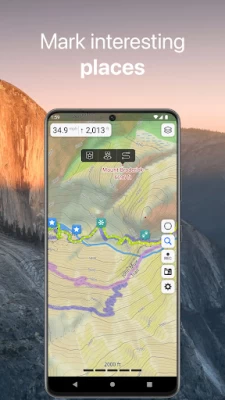
More About Guru Maps — GPS Route Planner
• High-resolution & based on OpenStreetMap (OSM) data.
• Updated monthly with the most-recent fixes and additions.
• Adjustable font size of the labels for better readability.
• Multiple custom map layers can be shown above the base one (GeoJSON support).
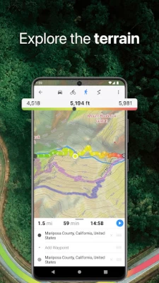
• Hillshade, contour lines and slope overlays for relief visualisation.
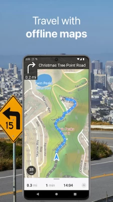
Offline Navigation
• Turn-by-turn voice-guided driving directions with alternate ways.
• Multi-stop navigation with the route optimization feature (circuit route planner).
• Voice instructions while navigating available in 9 languages.
• Routes for Driving/Cycling/Walking/Shortest Distance.
• Automatic rerouting gets you back along your way, even offline.
Drive Offroad
• There is an option for choosing the type of bike to build the perfect route, given the pavement (road surface): road, city, touring, mountain (MTB), trekking or gravel bikes.
• Plan an off-road overland trip in your 4x4 vehicle (quad, ATV, UTV, SUV, jeep) or moto, relying on topographic data in order to avoid trickier terrain. Find trails, campsites, adequate gas stations and other destinations along the route, even during an offline mode.
• The trip monitor shows the orientation (compass), accurate speed in mph, km/h or knots units (speedometer), distance (odometer), bearing line and azimuth during the trip. The app collects data from multiple satellites orbiting the Earth.
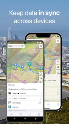
Synchronization
• Seamless sync your data across multiple iOS/Android devices as long as they are authorized with the same account.
• All the data such as saved places, recorded GPS tracks and created routes will be synced on all your devices on both OS platforms.
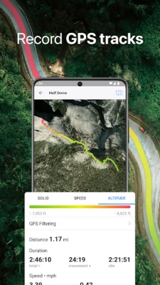
GPS Tracker
• Track the exact location of your phone & tablet real time.
• Record your footpath even when the app is in the background.
• Monitor detailed statistics of your ride: current speed, distance, time traveled, altitude.
• Choose from seven solid track colors, or altitude and speed gradients.
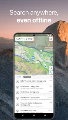
Offline Search
• Incredibly fast – results appear instantly as you type.
• Searches simultaneously in multiple languages, making searching easier than ever.
• Search in a variety of ways – by address, object name, category, or even by GPS coordinates. Supported coordinates formats: MGRS, UTM, Plus codes, DMS, latitude & longitude (decimal degrees (DD), degrees and decimal minutes, sexagesimal degree).
Online Maps
• Pre-installed online map sources: OpenCycleMap, HikeBikeMap, OpenBusMap, Wikimapia, CyclOSM, Mobile Atlas, HERE Hybrid (satellite), USGS - Topo, USGS - Satellite.
• Even more sources available for adding: OpenSeaMap, OpenTopoMap, ArcGIS, Google Maps, Bing, USGS etc from here: https://ms.gurumaps.app.
Supported File Formats
Support for a variety of file formats, including:
.GPX, .KML, .KMZ - for GPS-tracks, markers, routes or whole travel collections,
.MS, .XML - for custom map sources,
.SQLiteDB, .MBTiles - for offline raster maps,
.GeoJSON - for overlays.
PRO Subscription
• With a pro subscription, you'll have access to unlimited markers, GPS tracks, and offline map downloads, as well as additional sources and file formats.
• Without subscription it’s possible to create up to 15 pinned places, record up to 15 tracks and have only 3 vector countries (regions) downloaded on your device.
• Choose from monthly, yearly, or one-time purchase (aka lifetime license) options.
Latest Version
5.5.7
August 23, 2024
Evgen Bodunov
Travel & Local
Android
1,443,759
Free
com.bodunov.galileo
Report a Problem
User Reviews

A Google user
6 years ago
First impressions are of the ideal navigation aid for walkers and hikers. Its heads up (the ideal sat nav with the map orientated to the direction you are pointing the phone at) display especially in built up areas. It can be used offline after downloading your required map before setting off which is a must in remote locations without cell coverage.

David Palacio
4 years ago
This is THE offline map I was looking for. I have used it for a short time but I'm amazed of its good looks, intuitiveness, speed, good search. The only annoyance I have experienced so far is that it occasionally jumps to the current GPS location for no reason. It's almost certain I'm going to buy PRO in this app.

Tammy Norrie
3 years ago
Simply the very best mapping app around for detailed map navigation at locality level. Particularly good for outdoor activities, walking, hiking, etc. Providing feature rich mapping based upon OpenStreet and other map layers, which can be fully downloaded onto the phone. Much of this high quality app can be accessed completely free of charge. It really is excellent. It can also be used as a standard navigation tool for turn by turn instructed vehicle journeys over long distances..

G D
2 years ago
The app is great for mapping and bookmark management. However, it is sucks for hiking. For route planing It counts speed of human movement like constant, about 5 km / h, without taking into account height differences and terrain. Therefore, the planning of hiking routes gives erroneous calculations. This is a huge minus.

Thomas Jarvis
4 years ago
For my needs it has been perfect. I've used it all round the world when I have not had Internet connection and I need a map. I plot the places I want to go on the map before I leave an Internet connection then I basically read it as I would a paper map except I can always see where I am and there is a lot of detail. A very visually pleasing, user friendly interface. I couldn't imagine traveling without it.

Alexander
2 years ago
I like trekking in Central Asia mountains, and I tried many apps, as a backup for my Garmin. Some apps lack terrain lines, some lack information about natural obstacles like rivers, some don't allow import of tracks recorded by other people. Guru Maps has everything I need for trekking, and also decent offline city maps with cafés, gas stations, etc.

Smithsonian Rosterino
4 years ago
Great stuff. I've been using this app for about 6-7 years now. It's perfect for what I need. Easy to export all your pins and data if you upgrade your phone. I used Guru map as my primary navigation whilst driving through 52 countries. Great maps available for every country. The offline feature is really useful in remote areas with no internet access.

Silvana Nikolić
3 years ago
The maps are good, huge 👍 for possibility to download selected maps and use the app for an offline navigation. Two problems though, so I stay on 4* - suggestions for routes are now and then problematic, e.g., why are you sending me on goat paths (I'm driving)? Second - time estimates are as much as 50% off (underestimate). Needs an upgrade of the data base (road grade and speed limits) and some algorithm tweaking for routes. But I'll stick with you for now, keep on good job!

Cristi Gavrea
1 year ago
More a question than a review: is there any setting to render the OSMC symbol on the hiking routes? In my country this is very useful

Ranjith Balasuriya
1 year ago
The maps are working even offline is appreciated. Weakness are, The text on the maps difficult to read, and no facilities are made to watch the time line.

Stu Whitehill
1 year ago
Some minor adjustments to how I use it in a commercial vehicle, but definitely useable.

Steve Felton
1 year ago
The most useful and detailed GPS map I have used. I drove all around East Africa using it. But use your common sense too! Guru sometimes recommends a short cut down little-used tracks, and even with updates may not show new and better routes.

Glen
1 year ago
Fix these two things for five stars: 1. Movement direction orientation of map. This is crucial if using the map plan view whilst driving, without navigation prompts. The only method of orientation is compass, which swings around and is not usable. 2. The overall map information and contour lines become rendered at a far too small zoom factor. They need to be visible from at least 2x less zoom. It's near impossible to orient myself and nearby areas unless I zoom in further.
A Google user
6 years ago
- Route built through the points in REVERSE order (the point that I added first were considered at the end of the route) -- that was annoying - Coloured route in the bike mode is great, yet, I would suggest colourinng not the altitude, but gradient slope: I'm not interested in the altitude at which I'm biking, but I'm extremely interested in CHANGES of the altitude along the way - Orientation of streets' names need to adjust along with map's orientation (upside down names are hard to read)

Phil Strong
3 years ago
Unfortunately, in record mode it stops recording unless the screen is on, despite the fact that I have enabled it when display is off in the phone settings. Also, even when following it with display on the distances, altitudes and timings are all over the place. The maps are good however, and position looks accurate on map. Their tech support answer to these issues was phone is not supported, phone is fairly recent huawei P9 lite.

Kaza
3 years ago
Doesn't seem to have Android Auto support. Pretty easy to use and simple. Would actually like some more customization options about turning off things like elevation changes, which I really don't care about and always shows on the display taking up space. Pro version seems awfully expensive given the price and quality of other apps available.

Brent Hoskisson
1 year ago
Biggest issue is the phone turns off while you are using the app. Not very good for traveling. please include an option to keep the phone on when the app is visible. I'll add a star for fixing it. Searching is very slow. It also has a tendency to crash when the battery gets low. Finally it stops downloading when I go to other apps. Download really ought to be able to run when not using the program.

Sam Petty
4 years ago
Ive used this map for over 5 years now and no complaints. I like having the option of having an offline map, esp if signal strength is spotty. Easy to download whatever states (and I use Mexico too, but its not as useful as US maps) I may currently be traveling to, and if storage is limited on your device, delete the ones you wont be needing soon. I have not used the pro version - the free one is ok for me.

Jefry Ghazaleh
1 year ago
I use this app as the platform for the patrol department that I manage at work. I read the reviews and all the negative ones are issues that do not happen to me. User error? No, the app will not turn off randomly, or the record stop randomly, based on the devices wake state. Yes, there is a way to deselect the elevation and contour changes via settings. Please people, if you're going to review something - don't lie through your teeth about its capabilities. This is a marvelous app!!!!!!!!

Logan Kruse (Logi Wan)
1 year ago
One of the best free GPS navigation map apps that I've found. It could use some more work on making it easier and more streamline when trying to input, find, set up and then navigate to a new location or point on the map to have the app help you navigate to. Besides not being the most accessible nav app, it's got a LOT of choices and options to make use of. It's nice to be able to set up a map with a layer over the map to show other useful info, like weather or cellular coverage. 8.5/10


