

HiiKER: The Offline Hiking app
July 24, 2024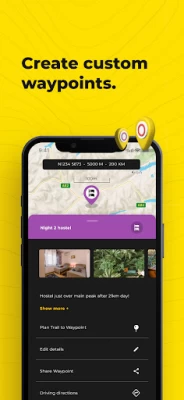
More About HiiKER: The Offline Hiking app
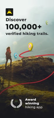
* Discover over 100,000 verified hiking trails
* Find campsites, hotels, huts, stores, motels, water sources etc
* Plan your own custom hiking route
* Record your Hikes
* Download hiking trails for FREE to navigate offline
* Create custom waypoints for Nav and Geocaching
* Import & Export GPX files for Free
* Choose from High-Resolution Map layers
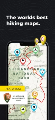
Download thousands of Hiking trail maps for FREE
With HiiKER, you can download over 87,000 of the world’s best hiking, walking and backpacking trails right to your smartphone for free. Looking for the perfect hiking trail? You’ll find the trail that’s right for you with our powerful trail search tool. And navigate it completely offline, for free.
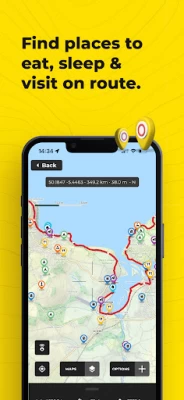
Points of Interest / Accommodation
You’ll find thousands of accommodation and amenity options for your adventures. Plan ahead with the perfect lunch spot, campsite, resupply town or maybe even a 5-star hotel on your hiking trip.
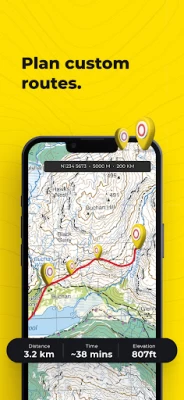
Plan custom hiking routes
The HiiKER Route Planner will enable you to blaze your own trail and plan a custom hiking route. Download your planned hiking route to your device for free and navigate offline. You can even share your hiking route with others or with your smart device, like Garmin, Apple watch or Google Fit.
Free Offline Hiking Maps
With HiiKER you can download all your favourite trails to your phone to use offline FOR FREE - even in airplane mode, so you can stay safe on the trail.
Waypoints & Geocaching
Place custom waypoints on any map and edit the details of the waypoint. Waypoints can be used to note campsites, gps coordinates, geocache locations, checkpoints and many other uses.
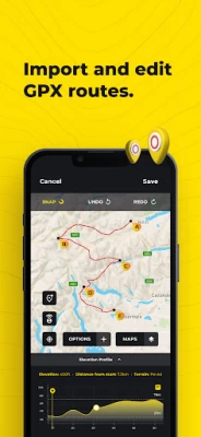
Import GPX files
Got a GPX file from a friend or another app like alltrails, onx, gaia gps, garmin, strava, komoot? Import it to HiiKER and make your own edits to the route before hitting the trail.
Record your Hikes
The HiiKER Tracker records your hiking activity and gives you in-depth detail about your adventures that you can share to Strava, Garmin and with your hiking community.
High-Resolution Map layers
We are building the most comprehensive selection of FREE map layers available. You'll find the layer that is best suited to your hike. These include
Open street maps (OSM)
Satellite
Nature
Mobile Atlas
Landscape
Pioneer
Transport
Free GPX Download
Export GPX files of one of the thousands of hiking trails on HiiKER for FREE. Sync them with your other gps devices, such as Garmin, suunto, coros etc.
HiiKER PRO+ pricing starts from $4.99 per month or $49.99 per year.
[PRO+] Measure the Distance
Use our handy measurement tool to know what distance, terrain and elevation lie ahead.
[PRO+] Stage by stage breakdown
Planning a longer hike and want to divide the trail into smaller segments? Our stage-by-stage breakdown helps you plan your days better with clever distance and elevation management.
[PRO+] Premium High-Resolution maps
Upgrading to HiiKER PRO+ gets you access to some of the world's best map developers in the world on the platform. These high-resolution maps include
US National Forests
USGS
National Park Service
Ordnance Survey UK
EastWest Mapping
IGN
OSi (Ireland) / Tailte
Swiss Topo
All of these maps can be used in conjunction with other HiiKER features.
Quality Data
We don’t just put any trail on HiiKER. We partner with trail organisations, National parks and other trusted sources around the world to bring you the most up-to-date and official trail data available.
These organisations are critical to the enjoyment and safety of hikers. As many are voluntary or NFP organisations, we give users the ability to donate to them for the valuable work they do.
Help and Support
Contact us at customer-support@hiiker.co
Legal
Terms of Service: https://hiiker.app/terms-of-service
Latest Version
5.46-559
July 24, 2024
Waymarked Trails LTD
Internet
Android
102,454
Free
com.waymarkedtrails.hiiker
Report a Problem
User Reviews

Jon Boy
4 years ago
Had an issue with the app crashing, reported to the team, fixed very promptly and good communication throughout. Reserving the 5* for when I've properly tested the app out in the field but from what i can see it's an excellent app with a lot of detail and great UI. Certainly a rival to guthook guides for the UK where they don't have as many trails covered.

Glenn Williams
2 years ago
Spent the day on a 25km hike, using Hiiker to track and record the adventure, only for it not to save at the end. No record of the hike, which was very frustrating. It's a shame because the app interface is clean and easy to use, with clear buttons for performing tasks such as start, pause, resume and stop. The search function suitably identifies established routes, which then track really accurately. The app even operated well in the background. Credit to Eoin for his swift response.

Richard Burbidge
2 years ago
I have great hope for this app. It has some great features, namely it has (free) access to the Thunderforest mapping as previously used by the sadly missed viewranger app, and (subscription) access to both OS maps and Harvey's maps. I've not found any other apps with the Harvey's mapping. Also great that is can be accessed from a PC browser - nice to plan routes on a big monitor. Few things to improve, eg: printing is only available from the app and I couldn't even get that working.

zagreb boris
2 years ago
I like idea of using elevation data from the map instead from GPS - it's more accurate. Only a few apps use this method. But the elevation data on the map in this app are very imprecise - they are not continuous, but "jump" in steps 30-50 m from one point to the next one (no values in between). And the worst thing - many times recording just stops! And the route is lost!!!

Gus King
1 year ago
Had a few software issues to start with but customer service was very quick to sort it out.

John Cocker
1 year ago
This app is full of promise. I love that you can get Harvey maps. The navigation tools are well laid out and work well. BUT I can’t print either from a pc or the mobile app (android). However, the real insult Is that “customer support” simply ignores you. An email request a month ago, with further requests for a response have resulted in one initial automated acknowledgement and absolutely nothing else! That’s what you get as a “Pro +” customer.

Sophie S
1 year ago
App does not search local areas or provide correct data. Even when given city and state it recommends trails a thousand miles away. The map shows the trail I want to hike today but app doesnt recognize that there is a trail. There are no landmark names or street names on the map, local hike attractions are not listed.

Corey Lehman
1 year ago
This app is liable to be sued for false advertising. They also charge $40/year for trail maps but they LIE about it in all the adverts

pat hogan
1 year ago
Excellent. First class maps.The best and it gives you the option of using Irish grid which all Irish map use. All Trails doesnt and maps are lacking in detail which means I got lost a few times and trails incorrectly named and many dont exist. There are a few blips on Hiiker but they are being sorted. I would highly recommend the Pro version. Stay safe. Pat Hogan

Marguerite Davey
1 year ago
Love this app as it allows access to all the East West maps which I use regularly. Even better it now has OSI maps for the areas not covered by East West. Very easy to plan routes or just get a quick idea of the distance and climb involved on any route. Probably most importantly Eoin gives wonderful support and responds really quickly when contacted. Definitely worth having.

Tom Fuller
1 year ago
The upgrade has not improved things. Under maps you have to choose between Hiking, National and Historic, with no explanation for these categories. I want to download East West maps but I don't know where they are. It is also not clear where you can download maps for other countries. I had hoped a revised Hiiker would deal with maps in the straightforward way that View Ranger did but alas they have made it even more obscure. Also they seem to have removed all means of giving feedback.

Josiah Spong
1 year ago
10/10 Great app with ever-improving features and great instantaneous customer review. Used in a professional capacity as a guide in remote mountain areas of Scotland and has been reliable and safe mapping app. Used for 2 yrs + so far and planning to continue.

james wright
1 year ago
This app, and website is amazing. It is so helpful, and their assistance if you have any queries or problems is really swift and great. I cannot praise them enough. You can che k out trails, customise what you want to see, record an activity too. What's not to love? I've lived this team since I first saw it being used on the YouTube channel: - Drunk on Wanderlust, with the lively Kerry. Check her channel out and see for yourselves. Hiiker. Thank you very much. I'm now a paid member 😊

Stephan Szwaj
1 year ago
I subscribed to Hiiker for a month hoping for a reliable hiking companion, but unfortunately, my experience was quite disappointing. Despite having a constant internet connection and downloading offline maps, the GPS often lost signal, making navigation unreliable. This issue persisted throughout my hikes, leading to frustration and wasted time.I appreciate the concept and potential of Hiiker, but the execution needs significant improvement. I hope the developers address these issues soon. Until

Brawtimes and Ridgelines
1 year ago
I've been using the app for around a year both as a Mountain Rescue Team member and for personal days. Favourite features are the range of mapping available (especially Harvey's), ease of creating a "go to" location/waypoint creation and the ease of recording a track plus the ability to share via WhatsApp. Having the rolling updated Grid Reference on the map screen is great. Improvements ~ being able to default to the map page as app launches and a long screen press to create a waypoint.

A Google user
5 years ago
Very cool app. Lots of good photos of the landscape, and easy to navigate. Gives you directions to the trail head, and being able to download the maps for offline use on the trail, with way points, and it's also got different options of routes you can take on each trail. Cool stuff!

Always Forward
4 years ago
I'm having a very bad experience with this app. I like the interface, the measurement tool and the 'drop pin' functions. -Once, the app simply wouldn't start until l connected to the Internet. It had to update (it was up to date until then). Luckily, the Kungsleden is very well marked. Had it happened in Scotland and wish me luck. - Poor map: Lacks simple, important, details. Disappointed.

Stefan Smits
3 years ago
The app worked fine for my hike in Scotland. The maps were clear and the height profile map was a nice feature. A nice addition would be if you could also see your location/progress on the height map. I would also prefer if it were possible to show all amenities on the map at the same time, or select which ones you would like to see, instead of just being able to select one categorie.

Too Clean
3 years ago
It was good until the update. Either the controls are hidden now, or you can't change the directions of trail, nor Km to miles anymore. I tried to use the measurement tool, and it wouldn't clear when I used the clear map options. There are other things too, but all I can say is booo! I did find the mile/km after you said where it was. The direction doesn't do anything to flip from NoBo/SoBo or Eb/Wb. There may be more to do, but this is just Not intuitive at all.

Eugene Brennan
1 year ago
I think I used this in Greece when hiking and it was useful, but I noticed that it clocks up distance and elevation when I'm not even moving, presumably due to inaccuracies in GPS positioning. So over a minute, it said I walked 270 feet and gained around 280 feet in elevation, even though I wasn't moving. Maybe the GPS receiver in a phone takes some time to acquire all satellites once the app is started or recording is selected. I need to do some more experiments.


