
Locus GIS offline land survey
September 11, 2024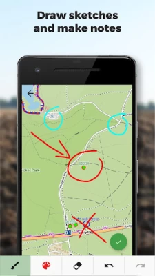
More About Locus GIS offline land survey
• offline collecting and updating of field data
• saving points with current or arbitrary position
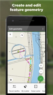
• creating lines and polygons by motion recording
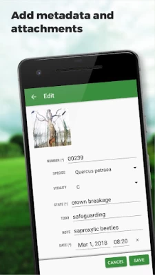
• settings of attributes
• photos, video/audio or drawings as attachments
• guidance to points
• collecting location data for polygon/line recording or guidance on a target, even when the app is running in the background
Import/Export
• importing and editing ESRI SHP files
• exporting data to ESRI SHP or CSV files
• exporting whole projects to QGIS
Maps
• wide range of maps both for online use and for download
• support of WMS sources
• support of offline maps in MBTiles, SQLite, MapsForge, TAR, GEMF, RMAP formats, and custom OpenStreetMap data or map themes
Tools and features
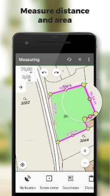
• measuring distances and areas
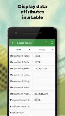
• searching and filtering of data in the attribute table
• style editing and text labels
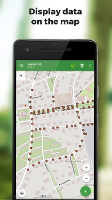
• organizing data into layers and projects
Locus GIS is successfully used in a wide range of industries:
• collection of environmental data (ecological scanning, tree surveys ...)
• forestry management and planning,
• agriculture and soil management
• gas and energy distribution
• planning and construction of wind farms
• exploration of mining fields and location of wells
• survey and management of urban facilities
• road constructions and maintenance
Latest Version
1.22.4
September 11, 2024
Asamm Software, s. r. o.
IT Tools
Android
650,530
Free
menion.android.locus.gis
Report a Problem
User Reviews

Soo Keat Lim
1 year ago
Good apps. Easy to use. Would the developer look into making it easier to change layers of same object? Thx.

Md Sulaimi Md Nor
3 years ago
Very good GIS app.. Why the latest version can not add layer using shp file from local storage? the problem is locus GIS can't read shp in local storage.

Harold Azlett
4 years ago
Latest update introduced a problem with displaying all polygons in an imported shp layer... Update- excellent, thank you - all 100%

A Google user
5 years ago
Sir The shape files already exported using old version was not used in the updated version. Kindly provide the necessary provisions. Thanks

J “Rabbit” J
1 year ago
Do not rely on this. Property lines are off by several feet. If you depend on this it could cost you depending on how you use it. It might be okay to get a basic idea but again, its off by several feet
A Google user
6 years ago
Really an awesome app for field work and works offline so you can check shape file data on your phone without having have arcgis.

Pete 1986
4 years ago
How do i change the map projection? When i export the shapefile and use it in Arcgis desktop the polygons ive created are not in the same place i created them? Edit: Thanks very much for the reply.

Owen Allpress
4 years ago
Best GIS app I've found thus far. Would be 5* if for in app support for a more featured import export that supports formats. Worth a look.

wan muhd Izwan
4 years ago
The apps not show the attribute detail when open the label. Then a few shp features not potrayed on interface. This happened when we update to v1.8.0

Mark Moness Biong
3 years ago
I use it for my stake-out surveys, very reliable. Also very flexible with shapefiles in different CRS. Still waiting for the update on accuracy filter tho.

Aldo Yulio
2 years ago
Great update, but there is some issues because not all phone has access to default categories in this new update, i guess because using android 13, and my gps on this app is kinda error because i already put my kmz on it but it is still really far on my display, is there any way to fix this issue?
A Google user
6 years ago
Very nice app that works flawlessly up to now. I would give 5 stars if there was a way to record automatically date, time, accuracy, elevation with tracks and way points.
A Google user
5 years ago
This app was one of the better GIS apps until Locus GIS stopped providing property information, such as the person/company that owns said property. Devs: while hovering the crosshairs over a building/or house, the screen would populate with the owner and/or the company name that owns said property. There's no way to send a screenshot because you've gotten rid of the feature. If you don't know your app well enough to know what I'm talking about, it's safe to say this problem won't be fixed.

Deddy Syefria
2 years ago
This app is perfect and stable enough. If I may, I request these features: 1. showing filtered features on map. 2. Enhanced filtering like able to filter empty or null attribute. Filtered by multiple attributes. And negative filtering. Good work!!

Darko Tripunovski
2 years ago
One of the best application for small firms and GIS students or enthusiasts, what you get for the price is outstanding and stability is on a level of the huge GIS software creators like ESRI, it only misses some lil simple things that would make it the best out there, and I am sure the creators are working on that and we would have them in the near future. Good job and keep it up!!

Parikshit Adkine
1 year ago
Very good app for gis field survey. Very easy to export and import data.

Martin Doktor
1 year ago
The app has big potential. A little bit fighting with UI and understanding all intended features. I would like to utilize two really simple user cases: 1. I am on unknown site and I would like to get and store precise location (with averaging feature and the best with NTRIP server), 2. I would like to drive a stake into the ground for a specific known coordinate (by compass feature with DGPS precision).

john grods
1 year ago
I have been doing mapping for several decades now. This is by far the greastest little app I have added to my toolbelt in a long time. Took a bit of time to figure out the processes, a manual to view offline would have been helpful. Looking forward to other upgrades and integrations.
A Google user
5 years ago
Such a great apps as it really assist my teammates and I in making data collection which in spatial, attributes and can also be attached with pictures. The developers also really responsive and helpful in giving the solutions of my problem by updating this apps into the latest version. I really enjoy using this apps and very recommended to be used especially for information that related to GIS. Thank you so much😀
A Google user
5 years ago
An excellent tool for any sort of field work which requires recording spatial data. Very easy to use and very powerful. Points, Lines and Shapes can be added in separate layers on top of your chosen base map in a variety of colours and styles. It is possible to define a list of attributes (like a form) for the individual points/lines/shapes within each layer. This allows the user to record a whole host of user-defined data about each spatial location as well as attaching multiple photos, videos and sketches to each point. Import/Export tools to external GIS programs allow the data to the consolidated and manipulated centrally. The free version comes with full functionality but with a limit of 2 map layers and 3 data layers, whereas the subscription version removes the limit on the number of layers.


