

Maplocs: Bike Route Planner
August 15, 2024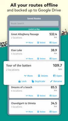
More About Maplocs: Bike Route Planner
FEATURES AT A GLANCE -
🚴 Build routes for road bikes, mountain bikes, city bikes and cars
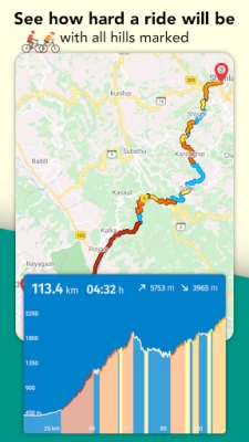
🚴 See elevation of entire route and in detail of each point or of part of a route
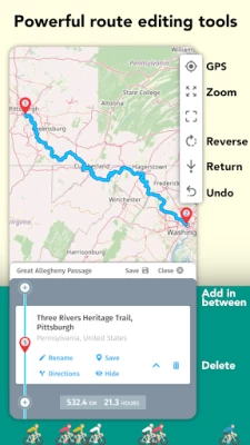
🚴 Powerful route editing with undo, close loop, add-in-between, reverse route, drag-and-drop to change and more
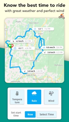
🚴 See weather along the route. Wind, rain and temperature.
🚴 Explore hills on the route. Hills are color coded with how difficult they are on the map and on the graph.
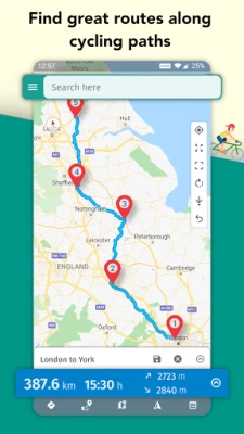
🚴 Google Maps, Open Street maps and Open Cycle Maps
🚴 Map customisation - show or hide markers, area names, street names, bus and railway stations
🚴 Show traffic - you can toggle live updated traffic data from Google on the map itself.
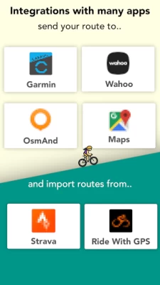
🚴 Send route to Garmin, Wahoo with a click.
🚴 Get routes from Strava and Ride-With-Gps.
🚴 Share route picture.
🚴 Lock and duplicate routes
🚴 Backup your routes to Google Drive
🚴 Sync routes between all your devices
🚴 Save places for easy access in lists and show entire lists on your map.
🚴 Powerful place search from Google & OpenStreetMaps.
🚴 Out riding, follow your routes easily and never get lost.
POWERFUL ROUTE EDITING FEATURES
We have designed the best route planning app for cycling. We built many features into Maplocs which makes editing a route very easy while keeping the app simple and very easy to use -
⚙️ Add points in between
⚙️ Delete points
⚙️ Close a route loop
⚙️ Shortest or fastest routing
⚙️ Long press and drag a point
⚙️ Reverse a route
⚙️ Duplicate a route
⚙️ Draw off-path routes
WE LOVE HILLS BUT WE ALSO HATE HILLS
Don't you just love the challenge of climbing a hill? We do too! Not only can you see total climb and decent, but also see the elevation and gradient at each point and sections of a route. Maplocs has complex algorithms which find all the hills on a route and colors codes based on difficulty. Hills are categorised from Cat 4, 3, 2, 1 to HC (Hors Categorie). Cat 4 is an easy climb while HC is a very very tough climb. We build this so that you know exactly whats on your route and are well prepared for it.
BEAUTIFUL CYCLING MAPS
What is route planning without amazing maps. We have Google Maps, Open Street Maps and Open Cycle Maps. There is no comparison to Google Maps when it comes to roads accuracy and places data. But there is nothing better than Open Cycle Maps for cycling routes and pathways around the world. We have them both! Additionally we also have satellite, terrain and specially designed dark and retro maps.
UNLOCK THE POWER OF GPX
We have embraced the GPX standard to create and share routes. You can export routes in GPX to be used in Garmins, Wahoos and many other devices. Also, you can import GPX files which will enable you to plan and navigate routes received in GPX from your friends, Strava or other websites like Komoot, RideWithGPS or MapMyRide.
YOUR ROUTES ALWAYS WITH YOU
Doesn't matter if you're bike touring in Europe, crossing the Hardknott Pass in UK or cycling the great MTB Divide across USA, your routes will always be available to you in the app offline. Also, never worry about losing your routes and back them up with Google Drive and even sync between all your devices.
You have questions? Contact us via maplocs@gmail.com anytime and we’ll get back to you as soon as possible.
Latest Version
2.23
August 15, 2024
Pedal Rhythm
Internet
Android
117,054
Free
abhiank.maplocs
Report a Problem
User Reviews

A Google user
5 years ago
The best road biking app. Able to plan routes using maps and simple touch screen. Imperial and metric plus elevation. View off line if you get lost without a mobile signal. SIMPLY SUPERB!!
A Google user
5 years ago
Better than most at defining a route, particularly now that you can move/fix waypoints. It's premium features are subscription based with no lifetime purchase option, pity as I avoid subscription like the plague...

Jonathan Mueller
5 years ago
Excellent way to map out your routes. Much easier to use and cheaper option than RidewithGPS. I also love that you can export to great Navigation apps so easily. Very affordable cost for what you get. Dev is constantly making it better!

Jasmin Crystal
3 years ago
it recommends roads I already know to be extremely dangerous for cyclists when there's a nearby hike & bike that isn't really out of the way. I don't mind sharing the road w/cars but I prefer it to be on streets that have two lanes, under 45mph, no blind switch backs with a single lane, & zero shoulder (not to mention the poorest lit area at night & floods easily). I recommend updating using data from VisionZero traffic fatalities to avoid dangerous, poorly constructed roads/intersections.
A Google user
5 years ago
I am doing a paper round and wanted to plan a route and all other apps failed-either you had to pay or they had a limit of stops or some addresses weren't in their database. This is perfect! And can be used for much more than cycling. A lot of options and a more detailed map than google maps. 5/5 from me! Good job! 😊👏

F. Egerer
3 years ago
I've tried a lot of cycle route planning apps. For now this has been the best, beating Komoot, Cycler, Bikemaps & all of the others. Why? Because it doesn't charge you for every single little feature, is usable & fast, allows to import/export and routes created are well balanced. Thanks for this good app! 👍
A Google user
5 years ago
Great, I use it for mapping my cycles and also for trying to calculate distances. The function that allows you to see elevation and descent has been a brilliant addition and makes it so handy for trying to plan in some climbs. I've recommended it to lots of friends
A Google user
6 years ago
The only reason I didn't give it 5 stars is because the Google maps tracking component seems to become confused when a route doubles back on itself. The end point can finish at a random location. For pure planning purposes this app is excellent.

Roberto Gondrong
5 years ago
I don't know other countries but useless in Indonesia. You cannot select locations manually to make a custom route, either you have to enter map coordinates (which is ridiculous) or search from the map (which doesn't work properly) searching addresses in USA not from my device location. Until there is a select points manually option, sorry waste of time.

Sri Suryawati
5 years ago
I love it. I like cycling in mountain areas and this application makes it possible to check the elevation along the route, and modify the points to get the desired distance and elevation. It took sometime to get used to it. When it does not recognize local map, I just click the points in the map to set the route. Done..
A Google user
6 years ago
Great app for planning routes and seeing the elevation, the recent update is a good improvement as it gives me the option to only take roads for my road bike rather than off road routes. Two minor improvements would be to show the elevation gain/loss between two points and also when looking at the elevation route in total having the option to see which markers are where on the total elevation to see where climbs/descents are.

Colin Cressy-Roberts
1 year ago
A great app to quickly plan routes and send to Garmin edge devices. Easy to use and integrated with google maps so you can search for places and generate and adapt routes quicker than on the Garmin edge device. Would be great if it could generate a circular route of a given km from a starting point and given general direction. Edit: auto route generation is now added! Only thing missing now is UK OS mapping view.

Jacob Wilson
4 years ago
Update - I had previously given a very low rating. The developer contacted me regarding the issues I had mentioned and he was very prompt in fixing all the problems. I will gladly continue to pay for the premium features as they are totally worth it, especially the weather along the route and hills on a route features. I whole heartedly recommend this app!
A Google user
7 years ago
This is really impressive. I am happy to find it. A few minor improvements will make it more useful. 1) The waypoints appear as 1, 2, 3 , etc. Is it possible to make the names of waypoints editable ? For example, edit "5 " as Peter's House ? 2 ) After the saved gpx file is opened in gpx viewer or other apps, the intermediate waypoints are not shown. Only the full track is displayed. 3) After saving a place, it remains permanently saved in the search suggestions. There should be a way to easily remove it from the search suggestions. Currently, to remove it, I erase the app data through android settings. Having said all these, this is a brilliant app with minimum permission requirements. Thanks to the developer !

Hendrian Septiadi
2 years ago
2 problems here. 1) test a 5km and 15km ride and for both, it create a maze route through many turns, narrow road and alleyway, compare to very straightforward route through the 4 way lane main road from google maps. 2) if you export route from google maps, the elevation does not showing. It will be magical, if this app can combine a route created by google maps, and the elevation is showing. I will definitively support and buy, if the app can solve this problem.

Ray Walsh
5 years ago
Great for drawing maps but must export for navigation, which would be fine if it played well with other apps. All the nav apps listed either cannot properly read the file (even exported gpx) or try to "optimize" it and do their own route plan, negating the good work this app does. Would give it 9 stars if it could also do turn by turn navigation.

A 0
4 years ago
ED Can you change the route between 2 points without adding new one? Frustrating for me. I want to be able to elect to override the given path of a route. If I know I am going to take my bike over in a ferry or skipping a certain road, I should be able to alter the suggested path. Also if I want to add a town between two pins, I should be able to add a new pin with a search for a town I know us somewhere between this pins. It might be good for short treks, but too limited for multi-day ones.

Daniel Levine
4 years ago
I've tried many bike navi apps & this is by far the best. It has loads of data & useful information & the route planner is fantastic. I'm always discovering new features. The dev updates often & they respond to questions & comments. The one gripe I have is the subscription fee model/recurring fees. Dev very kindly explained reasons for subscription model, which makes sense and the work deserves to be rewarded here!

Ryan Fortin (Ryan)
5 years ago
Hi, I'd say this is a great route planner. Thanks to the awesome developers for making it happen. Two 'features' that could be added, though. First a real app purchase, not a subscription. You'd have many potential buyers then 🤷♂️ Another is to add dark not only to the interface, but also to the map itself. Some of your 'route planning competitors' also have this so I think the devs could squeeze this little feature in.
A Google user
6 years ago
This is a great tool. Easy to use and very helpful when you want to avoid certain streets or to deviate from the normal route variations that google maps provide. The route you map will open in google maps and can be saved there. The route in Maplocs remains active and changeable even after saving in the app. So be careful when viewing a previously saved route in app, as it will continue to change if manipulated. The author,Ab, is considering a lock in future version. Very receptive


