

Outdooractive. Hike and Ride
August 18, 2024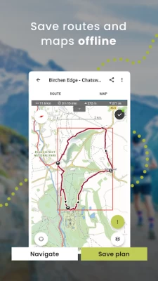
More About Outdooractive. Hike and Ride
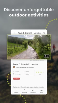
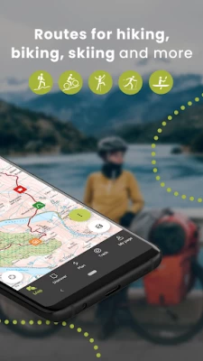
• Find routes you can rely on: Browse thousands of officially-approved routes near you and across the world, including routes for hiking, road cycling, bike touring, ski touring, gravel riding, trail running, horseback riding, mountaineering and more.
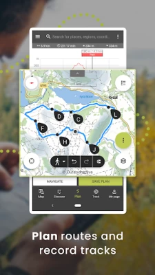
• Plan your own routes with tools trusted by professionals: Easily plot your own outdoor routes in the route planner in just a few taps, and see all need to know distance, elevation and terrain info.
• Save everything offline: Save individual plans or entire areas offline for reliable navigation when you don't have a phone signal.
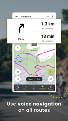
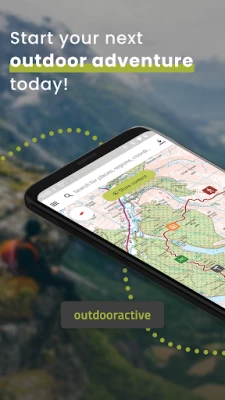
• Navigate with the most reliable maps on the planet: Browse the deepest collection of different map types to track or plan your adventures with confidence. Simply switch between different layers to get a clearer picture of the terrain you're planning to visit, and get the most reliable understanding of conditions on the ground. Outdooractive's map catalog currently includes:
Official topo maps in 25 countries, including:
Ordnance Survey (Landranger & Explorer) in the United Kingdom
New Zealand Land Information in NZ
USGS in the USA
BKG in Germany
BEV in Austria
Swisstopo in Switzerland
IGN in France
CNIG in Spain
PDOK in the Netherlands
Kartverket in Norway
Kortforsyningen in Denmark
Lantmäteriet in Sweden
Finland National Land Survey in Finland
GSI in Japan
Harvey Maps in the UK's most mountainous areas
The official Alpine Club maps for climbing in the Alps
The specially-designed Outdooractive map across France, Germany, Austria and Switzerland.
• Share your live location with family and friends: Give yourself and your loved ones complete peace of mind when you're out in the great outdoors thanks to BuddyBeacon.
• Join a global community of outdoor tourists and adventurers: Share your activities with the community, join challenges to stay motivated, and get inspired by officially-approved content from our thousands of industry partners.
• Smartwatches with WEAR OS from Google: With a glance at your Smartwatch, you get information about your GPS position on the map. You can record tracks, get tracking data and navigate along routes. Use the app tile to easily access nearby routes.
FAQs:
Can Outdooractive find walking trails near me?
Outdooractive helps you find walking, hiking, cycling and many more types of trails both in your area, and around the world.
How can I find hiking trails near me?:
Using Outdooractive, you're able to find hiking trails in your local area by opening our app and browsing the map. You'll be able to see hiking trails with a range of distances, difficulties and distance from your location.
How do I know which hiking trials close to me are best to follow?:
Using Outdooractive's multiple map layers, you're able to view official information from multiple sources, to inform you about trail conditions, rules, restrictions and what to expect on your hike. Experts will share information on each route on its difficulty, required experience level and more!
Can I download offline maps to navigate nature walks and areas to hike near me?:
Outdooractive allows you to download maps and routes to your device before heading out, to help you navigate those areas where signal isn't guaranteed — allowing you to reliably navigate the outdoors.
Latest Version
August 18, 2024
Outdooractive AG
Travel & Local
Android
3,873,104
Free
com.outdooractive.Outdooractive
Report a Problem
User Reviews

Christopher Nilsson
3 years ago
Latest version is full of bugs. Cannot trust the tracking feature anymore because it will always crash and ask if I want to restart the tracking. I choose yes, but as soon as I open another app (camera) and return, it crashes again. If I answer NO to restart, it restarts! Completely messed up! It shouldn't even crash! Today it took over 20min to obtain GPS signal. But if I opened Google Maps, my position was accurate and fluid. I'm seriously thinking on not renewing my subscription. Moving over.

Susan Sidell
3 years ago
Nope. Not a replacement for ViewRanger. Yes, it saved my previously saved tracks. I cannot download maps for offline use. And I dont really like the maps available for use that I can see. I'm a person who spends at least 50% of my time without cell connection, Hells Canyon is my backyard, i dont like this app nor its interface. Seems more like MySpace for mapping. And the ads are situated to get in the way of use. I've hiked 2000 ft up to a ridge top to get gps, dont lock up my app w/ ads

Elvis S
3 years ago
Kind of a bad replacement for viewranger. This not something I would trust for any serious outdoor activity. Maybe is good for parks and city walks. Maps are all very very bad. The outdooractive map and actually the whole app seems like it was created for kids. Missing lot of functionality when compared with viewranger. There are other apps out there you can trust, this one is not one of them right now.

Alan Winston
4 years ago
A very sad app. I am sorry that I started my Viewranger-subscriber trial now - I should have waited an update or two, because it will be wasted on the app as it is. The first thing I looked at was the maps, which are perhaps okay for France and Germany, but are rather poor for the United States. Before I got on the Pro+ trial, I wondered why they didn't have OpenTopoMap as an option, but it turns out that OTM is significantly better than their vaunted Pro map, and is widely available in cheaper and free apps. I have been using AlpineQuest, Locus Map 4, OsmAnd, Gaia (a sloppy mess, but still sometimes useful), and some others. I don't see any way this is going to be anywhere near the top of that list any time soon, if ever. From other reviews, they are going to ask me to contact support with details. Nope. Not worth the time and effort until I've seen some evidence of effort on their part. At half the annual cost, I'd be willing to take a deeper look at it, but not at a super-premium price. More gloss than guts. Skip it.

Michael Kimball
3 years ago
One of the best features of prior app Viewranger was the ability to select a map area without creating a route, and downloading a large region - for those times when you stray from a pre-determined route. With Outdooractive the map download feature automatically zooms to the limits of your route - why?? So you're forced to artificially create a dummy route to expand map area. Again - why? Loss of flexibility and features is hard to understand, maybe I'm missing something. De-coupling maps from routes gave VR much more versatility and user-friendliness - maybe this can be looked at for future versions. Edit: thanks for the tip, Outdooractive, I stand corrected. Updating to 4 stars.

Christian Mena
4 years ago
Very unimpressed with Outdooractive. Tracks are inaccurate. The same GPX loaded into ViewRanger yields a different result, which is always far closer to reality. Route planning accuracy can't be trusted. The user interface is cluttered. It runs slower than ViewRanger, it seems way too much emphasis was placed on graphics. Outdooractive Pro charges far more for the same features I got for 40% of the price in ViewRanger Pro, including more detailed maps. I have no incentive to make the switch.

John Rozmus
2 years ago
This is the app you're looking for if you want a GPS tracking map displayed on your smart watch (for free). I tried all of the other popular and recommended apps and none of them seem to have this feature, which I think is the most important feature of a wearable navigation app. For that reason alone, I rated this a 5/5, but the app also has a great interface, all the data you'd want, and many other great features. It does not have as good of a trail/route database as Alltrails.

Aleksandr Samoylov
4 years ago
Hard to tell how good it is. Does it import tracks saved in ViewRanger? When I try to "connect with ViewRanger" on login page it does not do anything! It simply cannot connect my premium account! In the menu you can find now "Ski Resorts" and "Accommodations" for which I see no need to be there. Anyway, in Taho, CA they return NOTHING. What is the point? I perceive this switch from ViewRanger as the switch from enthusiast application to something much more commercial. And finally - subscription price. $34/year while I had all what I need for $4.99/year. OK, good luck with that.

Brian Davies
2 years ago
I've been fooling around with this app for over a year and man, do I miss Viewranger. The interface is about as intuitive as a schematic for a super collider. Eg: How about a quick, simple way to save a single waypoint from the map screen (like your car or the boat launch), then a quick, simple way to navigate back to that WPT? Nope, can't do it, unless you start tracking FIRST?(!!) Has to be the most complicated, frustrating outdoor nav app out there. Sure wish Gaia worked on my watch.

Nathaniel Parker
4 years ago
I was a ViewRanger user for about 3-4 years, and I am an avid hiker. I used the OA app for the first time yesterday with my brother who is an inexperienced hiker. We tried testing the Buddy Beacon for safety. After accepting his invitation, the Buddy Beacon still won't work or acknowledge that I accepted his invitation. Also, for the US, elevation units are inconsistent. Many of the topo features are listed in meters until you zoom in to see them in feet. Trails are also mislabeled.

Jut Phish
2 years ago
I can't believe this happened. Shouldn't have turned off viewranger. App was perfect did exactly what I needed it to , saved me plenty of times when I was actually lost. I opened outdoor active 1 time realized you had to pay for any options that are helpful , leaving you with an undetailed white map to go off of. At least bring back the satellite view as a default. I'll struggle with Google maps if I'm lost before I pay for something I can access for free.

mk pkar
2 years ago
This forced replacement for Viewranger is terrible. It is designed for use in Europe (Germany) it has no information about US trails. Has only one option for type of maps to use, from time to time stops recording without notifying user, and can't be used offline. Why would anyone replace a good app(Viewranger) working well in the US with one that is flawed and is designed for use in Germany and force people to switch, then expect them to pay for it?

steve n
3 years ago
Why force us over from viewranger? The best feature of being able to see all your tracks on one map is not present on the app. Build that in and maybe I'll come back... It was such good navigational referennce and a personal collection of hiking and biking history. I had 7 years of tracks that i cherish for help to navigate and plan and I'll be looking for a replacement app now.

Ryan Mahoney
4 years ago
I will NEVER pay for a subscription. Pay model seems to want to be AllTrails, which I despise for so many reasons. VR had many features for free or 1x fee (saving maps for offline use being the best). This app is meant for regions of the world where cell reception is ubiquitous. My nearly exclusive use is backpacking in Wilderness areas and occasionally having to map my exit a few days into a trip. $34 USD per year for offline maps? Even All trails is only $30 USD /year. Get bent.

Smokey Bear GE
3 years ago
The app asked for login and password two times at startup. The bigger problem is that there is no map showing up in the background. A MAPPING app without a MAP is kind of a a serious problem. Grayed out map option choices cannot be selected for use. So, though there is theoretically a choice of map context backgrounds to choose, by selecting any one of them you only get to READ ABOUT the potential map choice, but you can never USE (SEE) your map choice. I am not a mapping idiot. 22yrs in GIS!!

Dave Marcellis
3 years ago
The selection of maps is underwhelming. Viewranger had licensed the latest USGS maps and a selection of osm maps that were very useful. I got my thirty day free pro subscription and there's really nothing available that's close. The USGS maps are so old they show highways that were demolished in the mid sixties. It's totally useless for my purposes. In addition, viewranger would show the altitude provided by the metadata for any point on the map, this app only uses gps for the current point.

Blake Veit
3 years ago
I made the trip over from ViewRanger, as many of us did, excited for a fresh face only to find an overly complicated and inferior app. Features I used often were quick and easy to access. Now I can't even find those features. Why is this harder to use than a TSA prescreening? And on top of that they want to charge a bunch of money for the privilege? Good luck with that... Thanks for ruining a perfectly good product.

Jeff Zaleski
3 years ago
Terrible both in form and function. Used VR until the day it was shut down, then cursed this "replacement" for the next 3 days of hiking. It would randomly zoom out to continent scale and stop tracks. Distance traveled has been moved to a small status bar and only displays ft/m units, which is worthless on a multi-mile hike. So much more that just doesn't make sense for the backcountry user. Will gladly pay subscription fees for CalTopo to get a usable GPS interface.

Frank Kennedy
3 years ago
Utterly impossible to figure out. Help files are completely wrong. The buttons and menus shown in the help do not exist. There is no distinct between the desktop and phone app help, so neither is ever correct. Even showed a T...p ad! Absolutely disgusting. And of course their response to this review is the boilerplate "email service" which means , "Go away. We do not care about ViewRanger lovers." Terrible replacement for ViewRanger.

Alexander Long
1 year ago
Doesn't really work well. Trying to plan a trip with a GPX I imported, but it's making it difficult to see any details on the map while having my route open at the same time. I can see the trail but not what towns it runs through for some reason without closing the route and only looking at the map. Its annoying to go back and forth. Wants me to pay for offline mode..was excited to use this app at first the app also doesn't translate. I can't find where I'm supposed to sleep!


