
Relief Maps - 3D GPS
August 04, 2024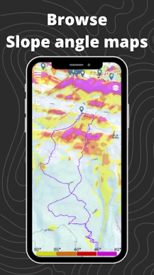
More About Relief Maps - 3D GPS
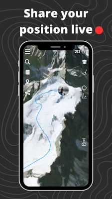
See the USGS maps as you've never seen it before in 3D!
Hiking to an area with no internet connection? No problem! Our gps app offers offline maps so you can continue your navigation even without a network. You can download USGS maps and use them in offline mode, so you'll always be sure of your position and direction.
Hiking :
Find hikes nearby, our route catalog will help you find interesting trails all around you, whether you just want to go for a stroll or a sporty hike.
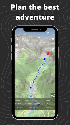
Our route planning system also lets you easily plot your own routes, then export them to GPX.
Mountaineering :
Consult camp-to-camp and skitour topos with GPS tracks and easily find the start of your dream route! From Mont Blanc to Aiguille Verte via the whymper couloir, climb every peak in the Alps!
Enjoy the best 3D visualization available on Chamonix and the French Alps.
Climbing:
Stop searching for hours for the start of a route! Find the start of a route with the GPX tracks available in the app.
Trek :
A trek lasting several days? You can plan your adventure easily with Relief Maps.
Find a list of points of interest that will help you, refuges, free parking lots, water points, toilets, campsites & bivouacs etc.
Find the best paths on our topo and IGN maps, and calculate the distance, altitude difference and duration of your route easily.
Whether you're trekking on the PCT or on the Appalachian Trail Relief Maps goes everywhere with you!
Ski touring :
Explore the mountains on skis with our ski touring tools.
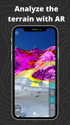
Analyze the terrain with augmented reality or 3D slope maps.
Take advantage of detailed weather forecasts with snowfall, temperatures by altitude, etc.
Consult skitour and camp-to-camp topos all over France and Europe.
Enjoy the best 3D visualization available on Chamonix and the French Alps.
Paragliding :
Used by many Xalps athletes, the app offers you all the tools you need for paragliding:
- Precise paragliding weather, wind, thermals, etc.
- Map of the best-known thermals
- Glide ratio calculator
- Live tracking
- Track replay
Downhill skiing:
- Find the piste maps of major resorts such as Park City, Breckenridge, Jackson Hole and many others.
Free features :
- 3D map consultation
- Route planning
- Nearby routes
- Hiking, walking, mountaineering, climbing, ski touring, mountain skiing, walking and paragliding routes
- Points of interest (refuges, water points, free parking, etc.)
- Track recording
- GPX track replay
- Track synchronization with Suunto watch
- Augmented reality
- Glide calculation (paragliding)
Premium :
- Off-line maps
- Livetracking
- IGN map
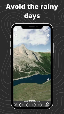
- Weather forecasts
- Route saving/tracking
- Slope maps (for avalanche risk in ski touring)
- Winter map
- USGS Maps
- GPX import/export
Maps:
- USGS topo
- USGS satellite
- 3D terrain
- IGN free map
- IGN scan
- IGN satellite
- Avalanche slope
- Satellite
- Swisstopo
- Swisstopo satellite
- osm summer
- osm winter
--
Premium subscription : 29.99€/an
Terms of use: https://reliefmaps.io/terms.html
Privacy policy: https://reliefmaps.io/privacy.html
Latest Version
2.0.7
August 04, 2024
Relief Maps
Travel & Local
Android
391,422
Free
fr.reliefmaps.app
Report a Problem
User Reviews

A Google user
6 years ago
Batiste is very helpful and responsive. Email him if you have questions. Definitely cool to see the 3d relief.

roi
1 year ago
Expect user customizable parameter to optionally exaggerate the steepness of the 3D map so as to easily perceive any slight steepness from the map. Thanks.

Teig Carlson
2 years ago
Grate replacement for "On X Tralls" it's free, easy to use, and grate graphics. I use this for every trail.

John Michael
2 years ago
Lasted about no more than 10 minutes, after opening the app up looking for my area and water the app crashed doesn't recognise anywhere in the UK but goes for EU I stead location was active and permission granted

GD Dowd
4 years ago
Downloaded app with 100% battery, used for an hour, 20% battery remaining. Phone was so hot to touch phyically i could have set fire to something. Removed app from phone forever.

Eric Katz
5 years ago
Cute app. Touch screen very laggy and intermittent. Expensive. Subscriptions required for each map and each feature.

Tomi Orban
4 years ago
i used it for 5 minutes then i closed it it was frustrating that whenever i wanted to use the main features i hat to buy the extension. Without them it is just an average map

Glen
1 year ago
Not a high quality piece of software. Extremely flawed UI/UX.

Hazem Elbatawy
1 year ago
excellent application with detailed contours.

Andrew Kiely
5 years ago
No addition over Google Earth or other mapping apps. Appearance is very basic. Covers France only, requires GPS and data to run. Not as user friendly an interface as Mapy.cz for example. Certainly better dedicated mapping apps available. Uses a total of 11.08kb of background data as opposed to GE using 875b.

Holly A
4 years ago
This is a very frustrating app! It constantly freezes up and has to be rebooted. It loses all my work and I have to start over again. I cannot get it to download the route as a video. Sadly, this really could be great but it is unreliable and very buggy.

WDB sirLocksight
1 year ago
Great App! Haven't checked all features. Accurate peak names in my Canadian Rockies locality. (ViewRanger closing. Finding different app for constructing routes and publishing them to a network.) For hyperlocal navigation with 3D view it seems this app would excel. Navigation velocity seems to be fixed | CONCERNS Map surface disappears at certain zoom levels like IGNSat | SUGGESTIONS Ground level Sat access in BasicLev (A) | FUTURE Test route nav (a) and GPX/KML upload (b).
A Google user
6 years ago
it's an indie app, and it's obviously not as packed with features as google maps for example. but it's amazing at the information it offeres. it's very easy to look around and understand the features you see with your eyes, and what their name is (in case of mountain peaks)

michele invernizzi
1 year ago
Great app. I use the free version, mainly when I land somewhere in the mountains with my paraglider. It works great (no annoying advertisment!). Always been able to find the path to get back to the main road (Google map is not so detailed). Easy to use and well done.

zagreb boris
2 years ago
Nice app, with not so nice maps - hundreds of peaks have wrong altitudes on the map - position of a peak is wrong (very often the peak is located 100-200 m off the real point, or altitude of a peak not corresponds to surrounding izohypses. So it's hard to say what is the real altitude of a peak. Fre version is VERY basic - no planning route, no download maps... no nothing. And Pro version is VERY expensive for me - 31 € every year! Not for me.

hossein korrani
1 year ago
A wonderful experience, for me being in Iran almost cut from all over the world, seeing trecks on remote mountains here was very cool. I use the free version since there is no possibility for us to pay for anything online here. There are sometimes some bugs at least on the free version. I will be more than happy to help find bugs for developers, my way to thank them.....

Mikołaj Kocot
4 years ago
The maps are impressive, both the terrain visualisation and the performance. However, everything else is very basic and not welll thought off. There is still a bit of work to make it a usable navigation app, maybe it's just missing good testers and people with expertise, if needed I could help. One typical example: you expand the stats bar from the bottom, now you want to close it, you click an (X) icon and that way you have lost your planned route , with no chances to cancel or redo it quickly. Planning the route itself is also a really bizzare process. .

Kostis Anagnostopoulos
1 year ago
Cannot work with non-latin (eg. fonts). No route elevation profile.

Kiefer Wallace
1 year ago
I am enjoying the interface and the "workshop" for self tracking and map building. Just pretty slow it seems. Other than that it's everything I wanted in a mapping toolkit imaging included

thew
2 years ago
Can't think any reason to opt for this app when Google Earth is simply better in every single conceivable way: better ui, smoother and higher quality graphics, more details & features, and settings options that actually work. This app can't even change from metric to imperial units: the option is listed in settings but elevations remain in metric measurements no matter. Lame.


